Vienna
Wien
Flag
Seal
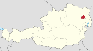
Location within Austria
Show map of Austria Location within Europe
Show map of Europe Coordinates: 48°12′N 16°22′E / 48.200°N 16.367°E / 48.200; 16.367 Country Austria State Vienna Government
• Body State and Municipality Diet • Mayor and Governor Michael Ludwig (SPÖ ) • Vice Mayor Christoph Wiederkehr (NEOS )Area • Capital city and state 414.78 km2 (160.15 sq mi) • Land 395.25 km2 (152.61 sq mi) • Water 19.39 km2 (7.49 sq mi) Elevation
151 (Lobau ) – 542 (Hermannskogel ) m (495–1,778 ft) Population • Capital city and state 1,888,776 • Rank 1st in Austria (6th in EU ) • Density 4,326.1/km2 (11,205/sq mi) • Metro
2,600,000 • Ethnicity[3] [4]
Demonym(s) German : Wiener (m), Wienerin (f) Viennese Time zone UTC+1 (CET ) • Summer (DST ) UTC+2 (CEST )Postal code ISO 3166 code AT-9 Vehicle registration W HDI (2018)0.940[6] very high · 1st GDP €94 billion (2017)[7] GDP per capita €50,000 (2017)[7] Seats in the Federal Council
GeoTLD .wien Website www Official name Historic Centre of Vienna Type Cultural Criteria ii, iv, vi Designated 2001 (25th session ) Reference no. 1033 UNESCO Region Europe and North America Endangered 2017 (2017 ) –present[8]
Vieno
germane Wien hungare Bécs latine Vindobona
ĉefurbo kaj federacia lando
Vieno
Oficiala nomo: Wien
Ŝtato
Aŭstrio
Historia regiono
Aŭstrio-Hungario
Flughaveno
Flughaveno Vieno
Najbaras kun
Malsupra Aŭstrio ĉirkaŭe
Urbaj distriktoj
Konataj lokoj
Ponto
Reichsbrücke
Riveroj
Danubo ,Vieno-rivero
Situo
Vieno
- koordinatoj
48° 12′ 32″ N 16° 22′ 21″ O / 48.20889 °N, 16.37250 °O / 48.20889; 16.37250 (mapo)
Plej alta punkto
- situo
Hermannskogel
- alteco
542 m s. m.
Plej malalta punkto
- situo
Lobau
- alteco
151 m s. m.
Areo
414,89 km² (41 489 ha )
Loĝantaro
1 712 903 (2010 )
Denseco
4 128,57 loĝ./km²
Parkoj
Danuba Parko ,Urboparko de Vieno, Viena Prater ,Esperanto-parko
Fondo
1-a jarcento
Urbestro
Michael Ludwig (SPÖ )
Horzono
CET (UTC+1)
- somera tempo
CET (UTC+2)
Poŝtkodo
1010–1239, 1400, 1450
Telefona antaŭkodo
01
Loko de Monda heredaĵo de UNESCO
Nomo
Historia urbocentro
Jaro
2001 (#25)
Numero
1033
Regiono
Eŭropo
Kriterioj
ii, vi, iv
Amuzparkoj
Wiener Prater, Böhmischer Prater
Wien
Retpaĝo: www.wien.gv.at
Wien
Stadt- und Landesflagge
Stadt- und Landeswappen
Logo
Basisdaten
Staat:
Österreich
Amtssprache :Deutsch
ISO 3166-2 :AT-9
UN/LOCODE :AT VIE
Kürzel, Kfz-Kennzeichen :
W
Gemeindekennzahl :
90001[1]
Gemeindecode :90101–92301[1]
Postleitzahlen :1010–1423, 1600,
Telefonvorwahl :01 (international: +43 1)
Website:
www.wien.gv.at
Geographie
Fläche :414,87 km²[2]
– davon Land:
395,57 km² (95,3 %)
– davon Wasser:
0 19,30 km² (4,7 %)[3]
– Rang :
9. von 9
Höchster Punkt
542 m ü. A. Hermannskogel )
Tiefster Punkt
151 m ü. A. Lobau )
Koordinaten
48° 12′ N , 16° 22′ O
Verwaltungsgliederung
Bundesland :1 Statutarstadt
Statutarstadt :23 Gemeindebezirke ,Katastralgemeinden
Lage Wiens in Österreich
Bevölkerung
Einwohner:
1.911.191 (1. Jänner 2020) [4]
– Ballungsraum :
2.838.558 (2018) [5]
– Rang :
1. von 9
Bevölkerungsdichte :4607 Einw. pro km²
Ausländeranteil :30,8 % (1. Jänner 2020) [6]
Migrationshintergrund :45,9 % (Ø 2019) [7]
Politik
Bürgermeister undLandeshauptmann :
Michael Ludwig (SPÖ )
Amtsführende Parteien:
SPÖ und NEOS
Sitzverteilung im Landtag und Gemeinderat
Letzte Wahl:
11. Oktober 2020
Nächste Wahl:
voraussichtlich 2025
Wirtschaft
Bruttoinlandsprodukt :96,42 Mrd. Euro (2018) [8]
BIP pro Kopf:
51.000 Euro (2018) [8]
Arbeitslosenquote :13,9 % (September 2020) [9]
Sehenswürdigkeiten


 English Wikipedia
 German Wikipedia